7.26.2011

SuperGIS Application to Emergency Response Digital Map Platform

This March, a massive earthquake caused a devastating explosion at Fukushima Daiichi nuclear plant in Japan and has brought catastrophic effects toward the locals. Radiation leaks following the blast have made many people homeless and triggered expansive fears around the world. The significance of nuclear safety, thus, begins to attract much attention.

In fact, Taiwan Power Company and the Atomic Energy Council of Executive Yuan, have dedicated much effort to developing a set of emergency response system for the three nuclear plants currently operating in Taiwan.

The authorities aim to set up a system that will provide information to the villages close to nuclear plants, and will increase the capability and efficiency of emergency responses during emergency times, and subsequently reduce the number of injuries and deaths to the lowest extent.
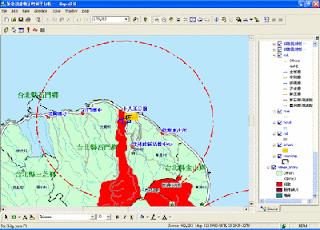

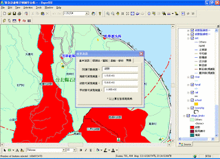
Using SuperGIS Desktop as the fundamental platform for updating and displaying data, the Emergency Response Digital Map Platform contains data of village census, locations of nuclear plants and radiation hospitals, evacuation routes, locations of emergency stations, gathering points and accommodation stations.

The government, integrating the data, such as census and nuclear plant locations, onto the GIS platform for display, browse and analysis, can import Excel tables that contain data on the radiation quantity into the system, and the system will read these data to automatically determine whether the villages should evacuate.

For the villages that require evacuation, the system can also dynamically display the gathering points, evacuation route and accommodation stations. With this function, the time for calculation and updating data can be reduced greatly, whereas emergency response decisions can be made much faster. This shall reduce the overall injuries, deaths and property losses.


For complete story of SuperGIS Desktop application to Emergency Response Digital Map Platform, please visit http://www.supergeotek.com/Library_2_200912.aspx

7.21.2011

SuperGIS Software Applied to Systemize Groundwater Recharge Potential Evaluation

Due to the terrain as well as poor water and soil conservation, that disastrous landslides occur in Taiwan after heavy rainfall has becoming a routine these years. And water resource protection, as a result, grows more important and urgent.

Ministry of Economic Affairs, Taiwan has launched hydrogeology studies in nine groundwater areas and built up groundwater investigation wells since 1991. The ministry collects the hydrogeology data, establishing hydrogeology database for researchers to monitor those natural groundwater recharge areas.

In order to elevate the accuracy of the delimiting of groundwater recharge area and the evaluation of recharge quantity, the government needs to have more detailed and complete monitoring data. Therefore, the authority seeks GIS technologies to create a groundwater recharge potential evaluation platform.


Applying SuperGIS Desktop and its extension—SuperGIS Spatial Analyst and SuperGIS Spatial Statistical Analyst, the Groundwater recharge potential evaluation platform possesses two main functions, Groundwater Hydrograph Recharge Evaluation and Groundwater Recharge Potential Evaluation.


This system utilizes the hydrograph changes of water table and tests the water pumped from the duplicate wells to calculate the pumping rate, recharge rate, water storage variations, and water loss rate in drainage regions. Furthermore, it employs multiple groundwater recharge factors to estimate the groundwater recharge potential of a certain drainage area.

With Groundwater recharge potential evaluation platform, the government is expected to not only improve the efficiency in the survey of water resource and reinforce groundwater preservation, but also bring down the damage from natural disasters toward the entire environment to the lowest extent.

For the complete story of this application, please visit http://www.supergeotek.com/Library_2_201010.aspx

7.12.2011

SuperWebGIS Utilized to Build Taipei Bus Information and Transit System

Taipei Bus Information and Transit System, constructed by Public Transportation Office, Taipei Government, has become an efficient tool for passengers to easily access the real-time bus information in recent year.

Applying Vehicle Positioning System, wireless communication devices, GIS, database and the web technology, the Taipei Bus Information and Transit System enable the public to gain the accurate information of bus movement and plan the best route.


This system adopts SuperWebGIS as the map server to publish maps and information about the movement of vehicles, Windows Server 2003 and Linux as the platform, and Microsoft Server SQL 2005 and Oracle as the media for saving the digital data.

Bus information like coordinates, speeds, directions and time, is collected from the devices on buses, analyzed by the backend software and is transited to the front end for users to query.

The functions of Taipei Bus Information and Transit System contain GIS Bus Route, GIS Trip Planner, Quick Search, Related Info and My Bus, which allows passengers to store frequently-used bus routes and set warning of arrival that greatly saves time in waiting a bus.


What’s more, bus operators can better manage and raise the operational efficiency of their fleet and dispatch mechanism, and subsequently improves the service quality through the system.

For complete story of SuperWebGIS application to Taipei Bus Information and Transit System, please visit http://www.supergeotek.com/Library_2_201007_4.aspx