11.26.2012

SuperGIS Desktop 3.1a Beta 4 Now Available


We are pleased to announce that SuperGIS Desktop 3.1a Beta 4 is available to help you display, edit, manage, query and analyze spatial data easily with its comprehensive and plentiful GIS tools and easy-to-use interface. Also, SuperGIS Desktop 3.1a enhances the manipulation of attribute table, map query, map navigation and so on.
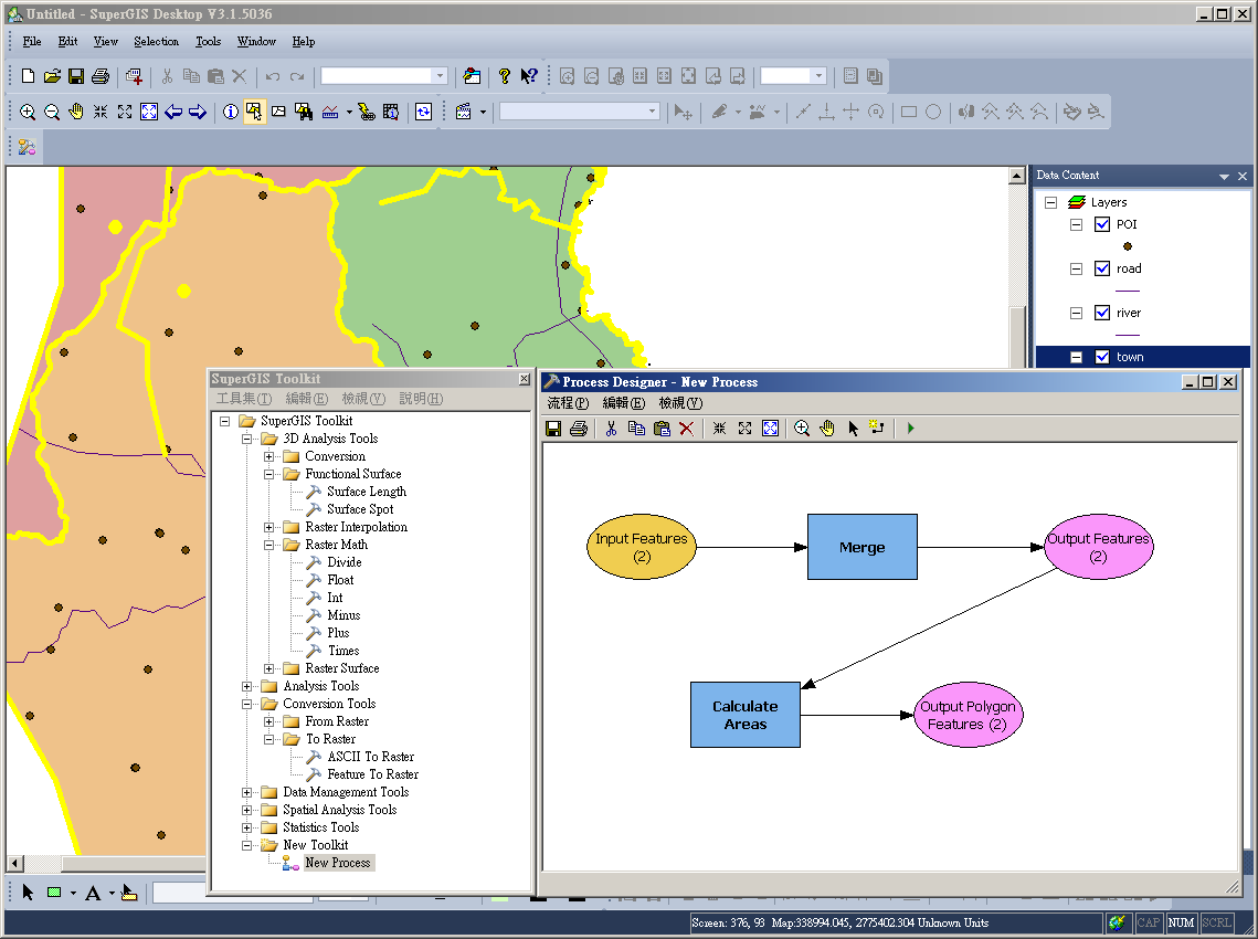
In addition to keeping improving the stability of manipulation, SuperGIS Desktop 3.1a Beta 4 adds SuperGIS Toolkit to provide hundreds of GIS analysis functions. Through employing Process Designer of SuperGIS Desktop 3.1a, users are not only able to define geoprocessing functions and workflows to meet their requirements but also process single data and batch data directly.


SuperGIS Toolkit provided by SuperGIS Desktop 3.1a not only improves the efficiency of processing spatial data and significantly decreases cost and time of the workforce. Besides, developers can apply the functions and workflows defined by SuperGIS Toolkit and work with SuperGIS Server 3.1 Standard Edition to publish the geoprocessing services to the front-end website so that users can utilize the GIS analysis functions with browsers with ease.

SuperGIS Desktop 3.1a will be officially launched soon. For more product information, please visit http://www.supergeotek.com/productpage_SG3.aspx

The free trial is available at http://www.supergeotek.com/download_6.aspx


11.19.2012

Android-powered Mobile Cadastral GIS 3.1 to Be Launched


We are pleased to announce that Mobile Cadastral GIS 3.1 for Android-powered devices will be launched soon in Taiwan. Designed to make efficient cadastral position, field survey and measurement, Mobile Cadastral GIS integrates with GIS, GPS, and e-compass technologies to help field surveyors quickly locate their current position and cadastral information to accomplish filed tasks effortlessly.

The newest Mobile Cadastral GIS 3.1 enhances query function that allows the field workforce to query cadastral information instantly by utilizing GPS, selecting, inputting cadastral information and so on. With Mobile Cadastral GIS 3.1, surveyors can easily obtain perimeter and area value of the section and cadastral data.

In addition, Mobile Cadastral GIS 3.1 will support the save function, enabling users to record the queried cadastral information. Therefore, the query results can be achieved and exported as TXT format for further application uses.

Mobile Cadastral GIS is available for conducting Cadastral data survey in Taiwan. The application has successfully assisted local governments in completing many survey tasks. For more product information about Mobile Cadastral GIS 3.1, please contact us at staff@supergeotek.com.

For more product information about SuperGIS software, please visit http://www.supergeotek.com/products_all_product_list.aspx

The free trial is available at http://www.supergeotek.com/download_6.aspx

11.13.2012

Web-based GIS for Campus Emergency Response


Accurate and reliable spatial information of an event nowadays plays a crucial role in minimizing human and asset losses. With the aim of preventing disastrous damage caused by sudden natural disasters, Chien Hsin University of Science and Technology, Taiwan, develops the hazard prevention Web GIS program for enhanced simulation and drills and effective emergency response during earthquakes, tsunami, and fires.

To help people improve preparedness and practice how to keep safe during earthquake strikes on campus, Chien Hsin University of Science and Technology conducts biannual earthquake and fire emergency response drills for nearly four thousand participants. The drills always put a strain on the Office of General Affairs.

Developed with SuperGIS Server 3 and Microsoft SQL Server 2008, the Web-Based Campus Emergency GIS System performs dynamic map display, basic GIS manipulation, and map navigation, delivering high quality spatial information for students and administrators in every department on campus to visualize, integrate, and analyze student population, facilities, and hazard data for better emergency planning and preparation.


The Web-based Campus Emergency GIS System is expected to integrate the information such as the evacuation routes, distribution of evacuation equipments and fire-fighting facilities, and lists of emergency personnel, to satisfy the requirements in class training and simulation drill of different situations. Therefore, a safe campus for study and work can be ensured and enhanced by means of GIS technologies.

More information about the application story, please visit http://www.supergeotek.com/Library_2_201211.aspx

More product information about SuperGIS Server 3, please visit

http://www.supergeotek.com/ProductPage_SGS3.aspx

11.05.2012

SuperGIS Server API Samples Available Now


System developers now can use plenty of SuperGIS API samples and object references to easily customize the map websites with SuperGIS Server 3.1.

With SuperGIS Server 3.1, you can create, manage, integrate, and publish various types of GIS services over the Internet to support desktop, mobile, and web applications. In addition, SuperGIS Server 3.1 offers JavaScript, Flex, and Silverlight APIs to customize map websites flexibly and effectively to meet demands in different cases.

In order to help developers to comprehend and apply SuperGIS Server API fleetly, we offer a variety of SuperGIS Server JavaScript APIs on SGDN website (SuperGeo Developer Network website). Every API sample provides comprehensive sample code and the live demo website, enabling developers to find the suitable sample efficiently according to the diverse topics.

SuperGIS Server Flex API and Silverlight API will be provided on SGDN website soon. A variety of SuperGIS Server API Samples are available at http://sgdn.supergeotek.com/supergis_server_api_JavaScript.aspx

SuperGeo GIS Forum: http://www.supergeotek.com/Forum/default.aspx?g=forum

For more product information about SuperGIS Server 3.1, please visit http://www.supergeotek.com/ProductPage_SGS3.aspx


The free trial is available at http://www.supergeotek.com/download_6.aspx