6.28.2011

SuperGIS Application to Wild Creature Data Management

As the technological development grows and the conservation consciousness rises, the Endemic Species Research Institute under Council of Agriculture at Executive Yuan in Taiwan has tried to find more effective approaches to preserve natural resources.


Under the cooperation between the Endemic Species Research Institute and SuperGeo Technologies, the Wild Creature Data Survey System is set up for efficent data management, and subsequently improves the conservation throughout Taiwan.

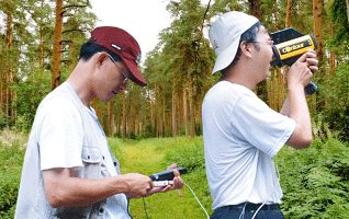
Adopting SuperGIS Mobile Engine as the core developing object, Wild Creature Data Survey System is mainly for filling in and submitting field data. It facilitates field surveyors to effectively create data, manage map and position on the mobile device with the user-friendly interface.

Surveyors can collect data swiftly by using this system installed in PDA, downloading data from the server or upload survey results to the server through synchronization with the server. In this way, the additional cost of processing survey data can be reduced.

The key functions this system provides include map navigation and position, swithing and managing maps, survey data management and GPS management.
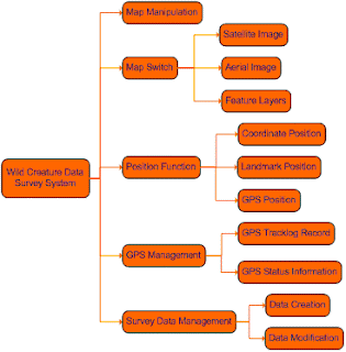


With the user-friendly interface, GPS function, and complete framework of Wild Creature Data Survey System, surveyors can collect and record data regarding domestic flora and flauna in the most effective way and meanwhile help improving the conservation in Taiwan.

For the complete story of Wild Creature Data Survey System, please visit http://www.supergeotek.com/Library_2_200907.aspx

6.21.2011

SuperGIS Mobile Tour 3.0 of Android version is Officially Released

Always troubled by the inconvenience and inaccuracy of tour information while traveling? The newly-released SuperGIS Mobile Tour 3.0 for Android, our first Android application may be the best solution.


As a mobile GIS application, SuperGIS Mobile Tour 3.0 is designed for outdoor mobile tour navigation. It is equipped with SuperGIS Mobile Tour Manager, providing users with various tour guidance to navigate and plan their journeys through Android operation system.

The main features of SuperGIS Mobile Tour 3.0 comprises clear interface, multuple display contents, such as video and audio in addition to text and images. In this way. users can obtain lively information of scenic spots, local hosts and websites more easily.


Besides, SuperGIS Mobile Tour 3.0 contains GPS navigation function, which can suggest suitable routes and keep tourists from dangerous areas. Meanwhile, people would enjoy more flexibilities in arranging their travels.


With SuperGIS Mobile Tour 3.0, users can experience the comprehensive support functions of for tour guide and improve the efficiency in planning their own journeys.

For the free trial of SuperGIS Mobile Tour 3.0, please visit www.supergeotek.com

More detailed introduction of SuperGIS Mobile Tour 3.0 is available at
http://www.supergeotek.com/ProductPage_SMT3.aspx?Type=Overview

6.16.2011

SuperWebGIS Applied to Set up Living Web for Yilan Recreation

With the increasing consideration for living quality these years, more and more people seek in-depth tour in holidays. Obviously, traveling has become an indispensable activity in many people's daily life, and tourism-related websites has been mushrooming accordingly.

Yilan, one of the most popular sites for tourists in Taiwan, is famous for its picturesque scenery and diverse natural resources. To allow the publics to experience and appreciate local cultures more easily and deeply, a website rich in variety and information is required.

A combination of WebGIS framework and multi-media technologies successfully contributes to Yilan Recreation and Living Web, a recreation website for tourists to query the travel and spatial information with much convenience.


Visiting the website integrating abundant information of sites within Yilan, people can access a wide range of travel information by GIS positioning function, and view detailed descriptions along with images of specific sites on the WebGIS platform without installing any plug-ins.

Different from other recreation websites which display the query results as static texts, numbers, and pictures, Yilan Recreation and Living Web shows query results with real-time video and multimedia, enabling users to get the latest information and feel like traveling in person. What's more, the website provides abundant information regarding guest houses in Yilan county.


For complete story of SuperWebGIS application to Yilan Recreation Living Web, please visit http://www.supergeotek.com/Library_2_201008_2.aspx

6.14.2011

Introduce SuperGIS Application - Helix Mobile Mapping System

We would like to share an outstanding application of SuperGIS! Helix S.r.l., our exclusive partner in Italy, has successfully developed Helix Mobile Mapping System (HMMs), a GIS platform for mapping and data collecting.


To provide localized GIS platforms for Italian mobile workers in collecting data and surveying in the field more effectively, Helix S.r.l. has established a system, which is named as HMMs, by applying highly flexible objects provided by SuperGIS products.

Being composed of HMMs Desktop and HMMs Mobile, HMMs can create the ideal workflow for local users who deal with data survey and civil services with SuperObjects and SuperGIS Mobile Engine.

With main features including creating and modifying map project importing raster and vector layers, querying vector layers and navigating the map, HMMs Desktop enables users to create projects that can be used with HMMs Mobile installed on mobile devices.

As to the HMMs Mobile, it allows users to perform the land survey and measurement in the field. The key functions of HMMs Mobile contain creating new vector layers and attributes, surveying with GPS and measuring distances and areas.


Considering data validity and availability, Helix S.r.l. also builds up a web application for permitted users to upload the real-time data to the server. Therefore, HMMs not only enhances the GIS workflow and but also enables users to upload the data effectively and ensure the data accuracy and security.

For complete introduction of SHMMs, please visit http://www.supergeotek.com/Library_2_201106.aspx

6.07.2011

SuperGeo Provides SuperGIS Training for Resellers from Romania and Grenada

We would like to share with you that we have successfully held SuperGIS training program for our resellers from Romanica and Grenada!

Our reseller in Romania, SC Molinaro Topo Expert S.r.l., provides clients with a wide range of land survey services froj cadastral surveys, topographic surveys to construction layouts.


As to another reseller, GYSFYN, who is authorized to distribute SuperGIS products in the Caribbean region, offers GIS and Geo-Date services including GIS Training, data capture, Web interface and GIS application development.


We are so delighted to have the opportunity to hold SuperGIS training program for the two resellers. During presentations, we endeavored to provide them with full support and information regarding the SuperGIS series software and meanwhile had pleasant communication with them.

Through the training, SC Molinaro Topo Expert S.r.l. and GYSFYN has gained further understanding of SuperGIS functions and applications. Aside from exchanging experiences and strengthening collaboration, we hope this event will benefit the achievement of SuperGIS product promotion in Romania and the Caribbean area.

Additionally, we would love to offer SuperGIS training for more resellers. If you would like to become one of the distributors of SuperGeo, please feel free to contact us (staff@supergeotek.com).

For more information of SuperGeo, please go to www.supergeotek.com