12.27.2011

GIS Applications: Discover Taipei in A More Convenient Way


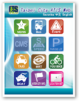
Tired of getting stuck in a traffic jam? In order to reduce traffic delays and promote tourism in Taipei, the Taipei City Department of Transportation cooperates with TMS Technologies to develop the Taipei City ATIS Website.


Previously, TMS Technologies has utilized SuperWebGIS as a developmental core of the GIS platform where the system can process and integrate spatial data from various departments and then broadcast the real-time traffic information to the public.


As a partner company of SuperGeo, TMS Technologies takes the advantages of GIS technical know-how and products offered by SuperGeo to build a GIS extension, ATIS, to promote urban traffic transmit and improve the transportation quality in Taipei.
Automatic Terminal Information Service, or ATIS, broadcasts the information about real-time road information, bus dynamic information system, and real-time available parking lot information.


Considering the booming popularity of smart phones, TMS Technologies has devoted to the development of mobile GIS applications. Therefore, an interesting and convenient App has been created to extend the application from Website to Mobile platforms for the public.


The App, called Easy Travel in Taipei, supports prevailing iOS, Android, and Windows Mobile operation systems. By using mobile devices, the public can not only obtain the real-time traffic information, but also plan your favorite cycling routes for relaxation with ease and fun.


For more information about the application story, please visit http://www.supergeotek.com/Library_2_201111.aspx

12.22.2011

GIS Application: Importance of Pollution Control


Have you ever been to Taiwan? Located in the north-east Taiwan, Yilan is a famous hot spot where visitors can enjoy its natural beauty, rich culture, and heritage.

To protect and preserve the valuable natural environment, recently we’ve cooperated with the Department of Environmental Protection Yilan and supported the project of improving the pollution control and management.

We’ve established a platform named Yilan Pollution Control GIS with SuperGIS Server allowing organizations to distribute GIS data and web services easily via the Internet.

The project is mainly to collect GIS data collection, develop prototype system, and ensure a smooth operation to meet the governor’s expectation.

The Environmental Pollution Control GIS platform currently focuses on integrating all kinds of pollution modeling analyses such as marine and air pollutions which enable decision-makers to combine the data with existing pollution layer for further application use.

Please visit at http://www.supergeotek.com/Library_2_201112.aspx for more information about Environmental Pollution Control GIS

12.01.2011

SuperGIS Mobile Solutions for Android and Windows Mobile


We are very excited to share new product plans with you. SuperGeo extends your mobile GIS platform to Android OS now.

Having been working on the mobile GIS software on Windows Mobile, SuperGeo now is developing several applications for Android OS.

In addition to current SuperGIS Mobile Tour, we will release SuperSurv, the data collection and survey software for Android devices, expected in one month (Dec 2011). The next product plan is SuperGIS Mobile Engine for Android (SDK).

For more details, please go to http://www.supergeotek.com/Mobile_Solution.aspx

The new product can be tested for free in Jan 2012. Welcome to download at www.supergeotek.com.

11.10.2011

SuperGeo Won Geospatial Excellence Award at Asia Geospatial Forum 2011


SuperGeo team just came back from Jakarta, Indonesia, for Asia Geospatial Forum 2011 event (formerly Map Asia). We are excited to share with you that one of SuperGIS applications has been selected for the 'Asian Geospatial Excellence Award’ in Transportation Management.

The awarded Web-GIS project, National Traffic Information System, integrates various kinds of real-time traffic information of each city/county and national freeways, such as speed information, CMS information, CCTV information, road events, etc. The system is authorized by the Institute of Transportation, MOTC, to assist the public in clearly querying real-time traffic information.


We also got many positive feedback and collaboration opportunities during the event. As the geospatial technology has shown considerable market potential in Asia, the event offered a great platform for the global geo-informatics community to acknowledge the edge of geospatial industry and further developed applications of crucial segments, such as Enterprise GIS, Cloud Computing, Remote Sensing, etc.


During the event, we showcased the latest SuperGIS Software and applications with our partners in Indonesia, PT. Jaya Kencana Perkasa as well as Datascrip, PT. We are confident that the exhibition will bring excellent marketing feedback in the promising Indonesian market and neighbor countries. We look forward to wider promotion of SuperGIS, the best alternative solution to ArcGIS, to more users in the world.


Further information about SuperGeo is available at www.supergeotek.com

10.16.2011

SuperGeo Showcased GIS Applications at ACRS 2011


Earlier this month, SuperGeo team was joining in ACRS 2011 in Taipei, Taiwan and attractors numerous interested visitors.

ACRS (Asian Conference on Remote Sensing) is one of the most important international conferences on remote sensing and geo-information fields in the Asia-Pacific area. This yeas was the 32nd event and took place in the Taipei International Convention Center, located at the center of Taipei.

During ACRS 2011, SuperGeo team showcased the latest SuperGIS software as well as applications to disaster control, emergency response, transportation management, natural resources, public health, tourism, etc. for international users from India, Thailand, China, Vietnam, Korean, Hong Kong, Mongolia, and also Taiwan.

As SuperGIS is considered one of the best alternative solutions of ArcGIS, numerous visitors have shown interests in SuperGIS software.

In addition, SuperGeo International Marketing Team will be exhibiting SuperGIS in Jakarta, Indonesia during Asia Geospatial Forum. We will promote GIS solutions with our Indonesia partners and also GeoEye team for the Lab Kit bundle. It’s exciting to meet more clients from more than 30 countries from Asia!

8.31.2011

SuperGeo to Launch SuperGIS Android Platform Solutions


SuperGeo Mobile Team has been observing the latest technology trend and developing our software accordingly. After several months planning, we are very excited to announce new product plans of SuperGIS for ‘Android solutions’:

In order to fit the mobile solutions in various platforms in the GIS industry, SuperGIS Mobile GIS product line has extended from Windows Mobile to Android operating system. Besides the current Mobile Cadastral GIS and SuperGIS Mobile Tour, SuperGeo is going to release SuperSurv and Android SDK soon.

In terms of Android platform, Mobile Cadastral GIS enables the staff in Land Office to rapidly get the current position and cadastral information in field survey. Another application, SuperGIS Mobile Tour, designed for outdoor navigation and tourism, integrates with multi-media for tourists to enjoy diverse route selections.

For the needs in collecting data in field survey, SuperGeo is developing SuperSurv.

The new mobile GIS application contains necessary field GIS functions for users to collect data and add point, line, polygon features with GPS signals. Also, SuperSurv supports the camera function on the mobile device. Surveyors can therefore enhance the data accuracy and enrich the data content quickly.

In addition to data collection functions with GPS, SuperSurv also supports surveyors to customize the menu according to different tasks. With the function, field surveyors are able to input the attributes easily and complete the data collection efficiently in various conditions.

In the near future, SuperGeo is going to release the SDK supporting Android platform. Developers or programmers who are able to develop applications can thus customize diversified more GIS applications for Android devices. More users owning Android system can thus select or develop ideal GIS applications easily by SuperGIS Android solutions.

The complete SuperGIS Android Platform solution is expected to be released in Q4 2011. More information is available on www.supergeotek.com.

7.26.2011

SuperGIS Application to Emergency Response Digital Map Platform

This March, a massive earthquake caused a devastating explosion at Fukushima Daiichi nuclear plant in Japan and has brought catastrophic effects toward the locals. Radiation leaks following the blast have made many people homeless and triggered expansive fears around the world. The significance of nuclear safety, thus, begins to attract much attention.

In fact, Taiwan Power Company and the Atomic Energy Council of Executive Yuan, have dedicated much effort to developing a set of emergency response system for the three nuclear plants currently operating in Taiwan.

The authorities aim to set up a system that will provide information to the villages close to nuclear plants, and will increase the capability and efficiency of emergency responses during emergency times, and subsequently reduce the number of injuries and deaths to the lowest extent.


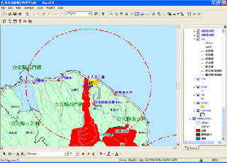
Using SuperGIS Desktop as the fundamental platform for updating and displaying data, the Emergency Response Digital Map Platform contains data of village census, locations of nuclear plants and radiation hospitals, evacuation routes, locations of emergency stations, gathering points and accommodation stations.

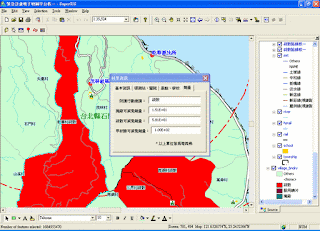
The government, integrating the data, such as census and nuclear plant locations, onto the GIS platform for display, browse and analysis, can import Excel tables that contain data on the radiation quantity into the system, and the system will read these data to automatically determine whether the villages should evacuate.

For the villages that require evacuation, the system can also dynamically display the gathering points, evacuation route and accommodation stations. With this function, the time for calculation and updating data can be reduced greatly, whereas emergency response decisions can be made much faster. This shall reduce the overall injuries, deaths and property losses.


For complete story of SuperGIS Desktop application to Emergency Response Digital Map Platform, please visit http://www.supergeotek.com/Library_2_200912.aspx

7.21.2011

SuperGIS Software Applied to Systemize Groundwater Recharge Potential Evaluation

Due to the terrain as well as poor water and soil conservation, that disastrous landslides occur in Taiwan after heavy rainfall has becoming a routine these years. And water resource protection, as a result, grows more important and urgent.

Ministry of Economic Affairs, Taiwan has launched hydrogeology studies in nine groundwater areas and built up groundwater investigation wells since 1991. The ministry collects the hydrogeology data, establishing hydrogeology database for researchers to monitor those natural groundwater recharge areas.

In order to elevate the accuracy of the delimiting of groundwater recharge area and the evaluation of recharge quantity, the government needs to have more detailed and complete monitoring data. Therefore, the authority seeks GIS technologies to create a groundwater recharge potential evaluation platform.


Applying SuperGIS Desktop and its extension—SuperGIS Spatial Analyst and SuperGIS Spatial Statistical Analyst, the Groundwater recharge potential evaluation platform possesses two main functions, Groundwater Hydrograph Recharge Evaluation and Groundwater Recharge Potential Evaluation.


This system utilizes the hydrograph changes of water table and tests the water pumped from the duplicate wells to calculate the pumping rate, recharge rate, water storage variations, and water loss rate in drainage regions. Furthermore, it employs multiple groundwater recharge factors to estimate the groundwater recharge potential of a certain drainage area.

With Groundwater recharge potential evaluation platform, the government is expected to not only improve the efficiency in the survey of water resource and reinforce groundwater preservation, but also bring down the damage from natural disasters toward the entire environment to the lowest extent.

For the complete story of this application, please visit http://www.supergeotek.com/Library_2_201010.aspx

7.12.2011

SuperWebGIS Utilized to Build Taipei Bus Information and Transit System

Taipei Bus Information and Transit System, constructed by Public Transportation Office, Taipei Government, has become an efficient tool for passengers to easily access the real-time bus information in recent year.

Applying Vehicle Positioning System, wireless communication devices, GIS, database and the web technology, the Taipei Bus Information and Transit System enable the public to gain the accurate information of bus movement and plan the best route.


This system adopts SuperWebGIS as the map server to publish maps and information about the movement of vehicles, Windows Server 2003 and Linux as the platform, and Microsoft Server SQL 2005 and Oracle as the media for saving the digital data.

Bus information like coordinates, speeds, directions and time, is collected from the devices on buses, analyzed by the backend software and is transited to the front end for users to query.

The functions of Taipei Bus Information and Transit System contain GIS Bus Route, GIS Trip Planner, Quick Search, Related Info and My Bus, which allows passengers to store frequently-used bus routes and set warning of arrival that greatly saves time in waiting a bus.


What’s more, bus operators can better manage and raise the operational efficiency of their fleet and dispatch mechanism, and subsequently improves the service quality through the system.

For complete story of SuperWebGIS application to Taipei Bus Information and Transit System, please visit http://www.supergeotek.com/Library_2_201007_4.aspx

6.28.2011

SuperGIS Application to Wild Creature Data Management

As the technological development grows and the conservation consciousness rises, the Endemic Species Research Institute under Council of Agriculture at Executive Yuan in Taiwan has tried to find more effective approaches to preserve natural resources.


Under the cooperation between the Endemic Species Research Institute and SuperGeo Technologies, the Wild Creature Data Survey System is set up for efficent data management, and subsequently improves the conservation throughout Taiwan.

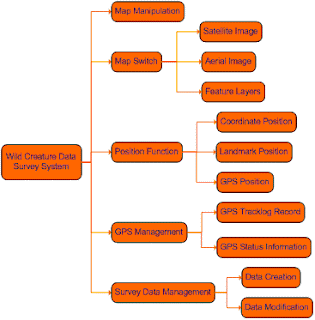
Adopting SuperGIS Mobile Engine as the core developing object, Wild Creature Data Survey System is mainly for filling in and submitting field data. It facilitates field surveyors to effectively create data, manage map and position on the mobile device with the user-friendly interface.

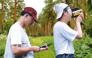
Surveyors can collect data swiftly by using this system installed in PDA, downloading data from the server or upload survey results to the server through synchronization with the server. In this way, the additional cost of processing survey data can be reduced.

The key functions this system provides include map navigation and position, swithing and managing maps, survey data management and GPS management.


With the user-friendly interface, GPS function, and complete framework of Wild Creature Data Survey System, surveyors can collect and record data regarding domestic flora and flauna in the most effective way and meanwhile help improving the conservation in Taiwan.

For the complete story of Wild Creature Data Survey System, please visit http://www.supergeotek.com/Library_2_200907.aspx

6.21.2011

SuperGIS Mobile Tour 3.0 of Android version is Officially Released

Always troubled by the inconvenience and inaccuracy of tour information while traveling? The newly-released SuperGIS Mobile Tour 3.0 for Android, our first Android application may be the best solution.


As a mobile GIS application, SuperGIS Mobile Tour 3.0 is designed for outdoor mobile tour navigation. It is equipped with SuperGIS Mobile Tour Manager, providing users with various tour guidance to navigate and plan their journeys through Android operation system.

The main features of SuperGIS Mobile Tour 3.0 comprises clear interface, multuple display contents, such as video and audio in addition to text and images. In this way. users can obtain lively information of scenic spots, local hosts and websites more easily.


Besides, SuperGIS Mobile Tour 3.0 contains GPS navigation function, which can suggest suitable routes and keep tourists from dangerous areas. Meanwhile, people would enjoy more flexibilities in arranging their travels.


With SuperGIS Mobile Tour 3.0, users can experience the comprehensive support functions of for tour guide and improve the efficiency in planning their own journeys.

For the free trial of SuperGIS Mobile Tour 3.0, please visit www.supergeotek.com

More detailed introduction of SuperGIS Mobile Tour 3.0 is available at
http://www.supergeotek.com/ProductPage_SMT3.aspx?Type=Overview

6.16.2011

SuperWebGIS Applied to Set up Living Web for Yilan Recreation

With the increasing consideration for living quality these years, more and more people seek in-depth tour in holidays. Obviously, traveling has become an indispensable activity in many people's daily life, and tourism-related websites has been mushrooming accordingly.

Yilan, one of the most popular sites for tourists in Taiwan, is famous for its picturesque scenery and diverse natural resources. To allow the publics to experience and appreciate local cultures more easily and deeply, a website rich in variety and information is required.

A combination of WebGIS framework and multi-media technologies successfully contributes to Yilan Recreation and Living Web, a recreation website for tourists to query the travel and spatial information with much convenience.


Visiting the website integrating abundant information of sites within Yilan, people can access a wide range of travel information by GIS positioning function, and view detailed descriptions along with images of specific sites on the WebGIS platform without installing any plug-ins.

Different from other recreation websites which display the query results as static texts, numbers, and pictures, Yilan Recreation and Living Web shows query results with real-time video and multimedia, enabling users to get the latest information and feel like traveling in person. What's more, the website provides abundant information regarding guest houses in Yilan county.


For complete story of SuperWebGIS application to Yilan Recreation Living Web, please visit http://www.supergeotek.com/Library_2_201008_2.aspx

6.14.2011

Introduce SuperGIS Application - Helix Mobile Mapping System

We would like to share an outstanding application of SuperGIS! Helix S.r.l., our exclusive partner in Italy, has successfully developed Helix Mobile Mapping System (HMMs), a GIS platform for mapping and data collecting.


To provide localized GIS platforms for Italian mobile workers in collecting data and surveying in the field more effectively, Helix S.r.l. has established a system, which is named as HMMs, by applying highly flexible objects provided by SuperGIS products.

Being composed of HMMs Desktop and HMMs Mobile, HMMs can create the ideal workflow for local users who deal with data survey and civil services with SuperObjects and SuperGIS Mobile Engine.

With main features including creating and modifying map project importing raster and vector layers, querying vector layers and navigating the map, HMMs Desktop enables users to create projects that can be used with HMMs Mobile installed on mobile devices.

As to the HMMs Mobile, it allows users to perform the land survey and measurement in the field. The key functions of HMMs Mobile contain creating new vector layers and attributes, surveying with GPS and measuring distances and areas.


Considering data validity and availability, Helix S.r.l. also builds up a web application for permitted users to upload the real-time data to the server. Therefore, HMMs not only enhances the GIS workflow and but also enables users to upload the data effectively and ensure the data accuracy and security.

For complete introduction of SHMMs, please visit http://www.supergeotek.com/Library_2_201106.aspx

6.07.2011

SuperGeo Provides SuperGIS Training for Resellers from Romania and Grenada

We would like to share with you that we have successfully held SuperGIS training program for our resellers from Romanica and Grenada!

Our reseller in Romania, SC Molinaro Topo Expert S.r.l., provides clients with a wide range of land survey services froj cadastral surveys, topographic surveys to construction layouts.


As to another reseller, GYSFYN, who is authorized to distribute SuperGIS products in the Caribbean region, offers GIS and Geo-Date services including GIS Training, data capture, Web interface and GIS application development.


We are so delighted to have the opportunity to hold SuperGIS training program for the two resellers. During presentations, we endeavored to provide them with full support and information regarding the SuperGIS series software and meanwhile had pleasant communication with them.

Through the training, SC Molinaro Topo Expert S.r.l. and GYSFYN has gained further understanding of SuperGIS functions and applications. Aside from exchanging experiences and strengthening collaboration, we hope this event will benefit the achievement of SuperGIS product promotion in Romania and the Caribbean area.

Additionally, we would love to offer SuperGIS training for more resellers. If you would like to become one of the distributors of SuperGeo, please feel free to contact us (staff@supergeotek.com).

For more information of SuperGeo, please go to www.supergeotek.com

5.31.2011

SuperGIS Server Provides Web APIs for Map Data Management

Are you seeking a more powerful platform for map resources management? SuperGIS Server is definitely a set of map server software you must try.


Designed for creating, managing, integrating and publishing GIS resources, SuperGIS Server greatly elevates the efficiency in processing geospatial data. Users can obtain almost any types of GIS resources they need from SuperGIS Server via the Internet.


To diversify the display of map websites, SuperGIS Server is now equipped with two Web Application Programming Interfaces (APIs), SuperGIS Server JavaScript API and SuperGIS Server Flex API.

These two types of Web API enable developers to access map services, develop webpage applications and customize map websites with more ease. In other words, with the Web APIs of SuperGIS Server, developers are able to create GIS platforms suitable for businesses.


In addition, if developers need detailed descriptions of each object and applied samples of SuperGIS Server, they can just refer to the Developer Guide attached to the software.


For complete introduction of SuperGIS Server Web APIs, please visit http://www.supergeotek.com/Library_1_201105.aspx

The latest free trial of SuperGIS Server is available at www.supergeotek.com

5.26.2011

Introduce SuperGeo's New Reseller in India


We couldn't be more pleased to share an exciting news with you! That is, we have found a new partner in India, RSI SOFTECH.

The main services of RSI SOFTECH ranges from remote sensing, survey to mapping applications. With its headquarters located in Hyderabad, RSI SOFTECH serves clients from the fields of business, agriculture, engineering, telecommunication, transportation, cadastral and cartography, etc.

Based on the expertise in Web GIS, Utility Mapping and Geospatial Data Mining Applications, RSI SOFTECH has become one of the leading providers of GIS, remote sensing and GPS hardware and software products and related services in India, Nepal, Bhutan and Bangladesh.

Having tested SuperGIS software, RSI SOFTECH is impressed by the comprehensive functions and high applied utility of SuperGIS products. Thus, RSI SOFTECH seeks the collaboration with SuperGeo in hopes of better serving its customers. Today, SuperGeo Technologies granted the resellership to RSI SOFTECH, who will promote SuperGIS series products in India.

India has saw the rapid growth of geospatial information industry in recent years. In view of this, SuperGeo technologies will hold SuperGIS training programs for RSI SOFTECH by the end of 2011, offering sufficient support to RSI SOFTECH in promoting SuperGIS products via multiple sale channels in India.

More information of RSI SOFTECH, please visit http://www.rsisoftech.com

More information about SuperGeo is available at www.supergeotek.com

5.23.2011

SuperGIS Server 3 Now Supports OGC Standards


We've got an exciting news for you! Our comprehensive server-based GIS software, SuperGIS Server 3, has passed Open Geospatial Consortium (OGC) official compliance test.

Following SuperWebGIS 3, SuperGIS Server 3 is granted the official certification of OGC. In orther words, SuperGIS Server 3 now supports Web Map Service (WMS), Web Coverage Service (WCS) and Web Feature Service (WFS) standards, which are defined by OGC.

The greatest advantage of this news is that for users with SuperGIS Desktop 3 and SuperPad 3, they can utilize the 2 front-end applications to access the OGC web map services released by SuperGIS Server 3 and directly read WMS and WFS services.

To be more specific, with these functions allowing the map data from diverse resources to be seamlessly integrated on the Internet, users can get geospatial data services more effectively, and also optimize the data usability.

In this way, both the interoperability of the SuperGIS products and the working efficiency of enterprises employing SuperGIS Server 3 can be considerably elevated.


More information of SuperGIS Server 3 is available at http://www.supergeotek.com/ProductPage_SGS3.aspx

Further information about SuperGeo, please visit www.supergeotek.com

5.19.2011

SuperGIS Application to Eco-Cultural Navigation

Another successful application with SuperGIS software! We have successfully set up Web-GIS, an Eco-cultural GIS website, to assist a local university in combining the campus navigation system with the features of surrounding environment.


To elevate teaching quality, Tungnan University is in need of a platform which can serve as both a database of local ecology and a system for campus navigation. By employing SuperWebGIS as the map server, we establish the Eco-cultural Web-GIS.

The Eco-cultural Web-GIS has a user-friendly interface, with its webpage being divided into two major sections: the map display area on the left and the Google Earth display area on the right. In addition to Google Earth, this website can display maps including e-maps, satellite images, Google Earth 3D buildings, etc.


Connecting to the website, users can easily get detailed eco-cultural information around the campus with query and map manipulation functions, like pan, zoom in/out, zoom to full extent.

Instructors can integrate the system with courses to help students understand GIS related knowledge. What's more, the public can also view specific tourism information of locations nearby the campus, such as scenic spot, the name of store, address, and phone number, etc.

With the Eco-cultural Web-GIS website, not only students' knowledge of GIS data collecting and managing can be greatly enriched, but the area nearby campus can gain benefits regarding its development and resources conservation.


To read the full story, please visit http://www.supergeotek.com/Library_2_201105.aspx

5.03.2011

Introduce SuperGeo's New Reseller in Romania


We are much delighted to introduce our latest partner in Romania, SC Molinaro Topo Expert S.r.l., to you.

SC Molinaro Topo Expert S.r.l. is located in Brasov, a city of Romania. Since being founded in 2007, this company has been providing clients with land survey services including cadastral survey, engineerng survey and topographic survey.

The corporation's manager, Ionel Vrinceanu, has been working as a surveyor since studying in America. During the process, he has accummulated vast experiences of land survey services, from boundary, topographic and Alta surveys to complex highways and construction layouts.

Although there are more and more firms engaging in GIS industry arises in Romania, the locals still lack sufficient knowledge of Geographic Information System. Having recognized this situation, SC Molinaro Topo Expert S.r.l. actively seeks to collaborate with SuperGeo Technologies.

In view of this company's ambition to promote SuperGIS software which are highly-efficient and reasonably-priced in Romania, SuperGeo Technologies today officially granted the resellership to SC Molinaro Topo Expert S.r.l., who will distribute SuperGIS series products in the local area.

Aside from boosting the development of GIS and promote SuperGIS series products in Romania, SC Molinaro Topo Expert S.r.l. plans to strengthen its cooperation with the academic institutes and governmental agencies in Romania, assisting them in proceeding land use, urban planning and cadastral management, etc.

For more information of SC Molinaro Topo Expert S.r.l. , please visit www.expert-topo.ro/en/

More information about SuperGeo is available at www.supergeotek.com

4.28.2011

Map Middle East 2011 in Qatar


Guess what? SuperGeo team just back from Map Middle East 2011! We must say “Impressive and pleaseant.” was the best description for the experience!


Map Middle East 2011 was held in Doha, State of Qatar, lasting from April 17-19. With the theme “Regional Spatial Data Infrastructure and Capacity Building”, the event provides an platform for international geospatial community to gather experts for discussing the challenge and the future of geospatial industry.

What was different from the exhibitions SuperGeo attended before, we co-exhibit with our important partners from Kuwait, UAE, Bahrain, Saudi Arabia, etc. in the conference. And this revealed our strong network in the Middle East.


During the event, we not only displayed SDI related applications by SuperGIS software, but also discussed with many government sectors, private firms, and educational institutes.

Having made a comprehensive self-introduction to all visitors, we expect to construct more collaboration with local businesses and gain potential opportunities in promoting SuperGIS products to enhance the development in the Middle East.


For more information, please visit http://www.mapmiddleeast.org/

More information about SuperGeo is available at www.supergeotek.com

SuperGeo Attended Map Malaysia 2011


We have been looked forward to share with you that SuperGeo team had participated in Map Malaysia 2011 in Sabah, Malaysia, during April 6-7.

Map Malaysia 2011 was jointly held by “GIS Development” and “Lands and Surveys Department Sabah”, with the theme set as “Empowering Nation through Geospatial”. It covered wide aspects of geospatial technology in supporting the sustainable development of various fields in Malaysia.


In the event, SuperGeo Malaysia, the first subsidiary company of SuperGeo Technologies, was endeavoring to demonstrate the latest SuperGIS software along with the applications for all the participants.


To SuperGeo, the exhibition was really a precious opportunity to exchange opinions with geo-informatics communities and explore to what extent GIS applications could contribute to human beings.

Additionally, we truly harvested a lot by communicating with delegates from diverse categories in GIS industry, and the experience helped us to further understand the need of local users.


For more information, please visit http://mapmalaysia.org/

More information about SuperGeo is available at www.supergeotek.com

SuperGeo At Geospatial World Forum in India


SuperGeo team was joining in Geospatial World Forum in Hyderabad, India, from January 18 to 21.

During the event, SuperGeo team showcased the latest SuperGIS software and applications, and successfully caught much attention from numerous visitors.


Organized by GIS Development, one of the most renowned geospatial communication network companies, Geospatial World Forum offered a platform for global geospatial community and users to communicate.


With the aim of promoting GIS applications, SuperGeo team was delighted to attend the forum. We met a great number of representatives and had pleasure talks with them. What's more, through the demonstration of the latest SuperGIS software, we established the initial connection with many potential customers and prospective partners in the fair.


One thing worth mentioning was that to praise the enterprise that have made lots of contribution in geospatial industry, GIS Development especially held Geospatial Excellence Awards. And SuperGeo felt greatly appreciated that our GIS technology and applications were one of the candidates of the honor!


For more information, please visit http://www.geospatialworldforum.org/

More information about SuperGeo is available at www.supergeotek.com